|
|
TODAY.AZ / Weird / Interesting
New Video of Earth at Night released- VIDEO
06 December 2012 [13:24] - TODAY.AZ
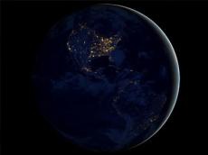
 Even at night, our planet is never completely dark. Light pollution is something we try to get away from when viewing the night sky. Now imagine how the night side of Earth looks from space. One of NASA’s satellites took on the task to map out this scene in an attempt to help study human activity.
A new video released by NASA and the National Oceanic and Atmosphere Administration (NOAA) offers an unprecedented look at the entirety of the Earth's nighttime surface as seen from outer space.
The 30-second video stitches together 2.5 terabytes of image data taken during 312 orbits of the planet by NASA's Suomi NPP satellite, which was launched in October 2011.
The video opens with a view of the Asia-Pacific rim, with the city lights of Japan and the heavily populated areas of China's coastal regions near the center of the frame. The Earth's rotation then brings the lights of the Indian subcontinent and the Middle East into view, followed by Europe and the mostly-dark continent of Africa.
Finally, the Americas rotate into view, with the heavily-populated eastern United States outshining the western half of the country and the most densely populated areas of Central and South America.
Light from auroras, wildfires, and other stray light sources were filtered from the video in order to emphasize the city lights. “Nothing tells us more about the spread of humans across the Earth than city lights,” said NOAA scientist Chris Elvidge. “Even after 20 years, I'm always amazed at what city light images show us about human activity.”
Data from the Suomi NPP satellite is used to provide government weather authorities with advance notice of the potential for dangerous weather conditions.
URL: http://www.today.az/news/interesting/116201.html
 Print version
Views: 1912
Connect with us. Get latest news and updates.
See Also
- 19 February 2025 [22:20]
Visa and Mastercard can return to Russia, but with restrictions - 05 February 2025 [19:41]
Japan plans to negotiate with Trump to increase LNG imports from United States - 23 January 2025 [23:20]
Dubai once again named cleanest city in the world - 06 December 2024 [22:20]
Are scented candles harmful to health? - 23 November 2024 [14:11]
Magnitude 4.5 earthquake hits Azerbaijan's Lachin - 20 November 2024 [23:30]
Launch vehicle with prototype of Starship made its sixth test flight - 27 October 2024 [09:00]
Fuel prices expected to rise in Sweden - 24 October 2024 [19:14]
Turkiye strikes terror targets in Iraq and Syria - 23 October 2024 [23:46]
Kazakhstan supplied almost entire volume of oil planned for 2024 to Germany in 9 months - 23 October 2024 [22:17]
Taiwan reported passage of Chinese Navy aircraft carrier near island
Most Popular
 What von der Leyen doesn't know about. Or doesn't want to know
 Culture Minister meets with Kyrgyz counterpart in Bishkek
 Japan grants $3 billion loan to Ukraine using profits from frozen Russian assets
 At least 148 dead after boat accident on DR Congo river
 Uzbekistan, South Korea discuss easing visa rules, expanding seasonal work opportunities
 Trump sees hope for Ukraine-Russia deal, analysts remain skeptical
 Syria president hosts Republican US congressman in Damascus
