|
|
TODAY.AZ / Society
Ancient maps found in Egypt show Armenia was too far from its present territory
25 January 2010 [18:13] - TODAY.AZ
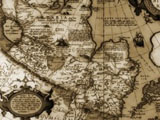 Director of the Institute of Oriental Studies of Azerbaijan National Academy of Sciences Govhar Bakhshaliyeva has found out valuable maps important for Azerbaijan’s history in Dar Al-Kutub library of Egypt. Spokesman for the Institute Vugar Mammadov said Bakhshaliyeva found out five maps important for Azerbaijan’s history, took their photos and brought them to Baku.
 Mammadov said that the maps show that Armenia was too far from its present territory, in the south.
He said one of the maps was published by A.Tarid in Boulevard Saint Denis early in the past century. The map was developed to show the railways and navigation lines of the European and Asian countries.
The territory of the state described on the west coasts of the Caspian Sea and presented as Azerbaijan on the map coincides with the territory of Azerbaijan People’s Republic (1918-1920). The disputable areas are also presented as Azerbaijan’s territory on Tarid’s map. The map confirms that Nagorno-Karabakh, including Shusha belong to Azerbaijan and also shows Derbent, Gasimkend and other upper territories as Azerbaijan’s territory.
The country’s western border passes through the Goycha Lake. The regions of modern Armenia – Mehri, Gafan, Gorus, Sisyan, Vardenis, Krasnoselsk, as well as part of Berd region, are shown as the Azerbaijani territory. Another map shows Iranian territory after the Gulustan and Turkmenchay treaties. The map was drawn up in Farsi.
The toponym of Azerbaijan is shown as covering an area from the banks of Araz River until the Iraqi borders. The mountains of Ahar, Marand, Savalan, Lake of Urmia, cities of Maraga, Mahabad, Maku, Khoy, Ardabil, Miyana, Tebriz and others are shown as territory of Azerbaijan.
The third map was drawn up in 1785 in Venice, Italy. It was called as “Empire of Alexander the Great”, which covers Europe, Africa and Asia. The map was drawn up in Italian by Antonio Zatta and his sons. Albania was shown in the western coast of Caspian Sea.
Armenia was shown not as a state, but only as geographic territory in very south of Araz River, in neighborhood with Assyria and Mesopotamia.
The next two maps were drawn up in Amsterdam, the Netherlands during the Ottoman Emperor Mehmet III’s rule. (1595-1603). It was drawn up by the artist Jydykus, Hindius. Another map was drawn up and printed by the artist Friedrich de Wit in 1775. The maps show Armenian territories far from their present location in the south and having no relation to the territory of modern Armenia.
/APA/
URL: http://www.today.az/news/society/60155.html
 Print version
Views: 2898
Connect with us. Get latest news and updates.
See Also
- 13 February 2025 [14:37]
Baku’s ADA University and Partners to host 2025 ICPC World Finals - 13 February 2025 [11:02]
State Agency completes major reconstruction of Keremli Automobile Road - 13 February 2025 [10:15]
Exploring vesugen: cellular aging and metabolism - 10 February 2025 [10:18]
Ship operations in Caspian Sea fully resumed after weather stabilizes - 08 February 2025 [17:00]
Azerbaijan's Health Ministry launches HIV prevention syringe initiative - 08 February 2025 [16:30]
MES launches nationwide safety awareness campaign in schools - 08 February 2025 [14:20]
Azerbaijan Army’s marines participate in AMAN-25 Exercise and AMAN Dialogue - 08 February 2025 [13:45]
Students in Khankendi informed about consequences of harmful habits - 08 February 2025 [13:15]
Cooperation issues with International Turkic Academy discussed - 08 February 2025 [12:40]
Azercosmos hosts Aerospace and Digital Innovations Forum for high school students
Most Popular
 Armenians are preparing for a "crusade" against Baku – hopes for the United States
 Ruins of an Azerbaijani mosque are being desecrated in Yerevan
 Azerbaijan rejects Armenian PM's claims, calls out military buildup and territorial ambitions
 Military personnel awarded for excellence in Winter Exercise-2025
 President Ilham Aliyev held expanded meeting over lunch with Somali President
 Foreign Ministers of China, South Korea and Japan hold meeting in Tokyo
 Trial of Armenian war criminals continues in Baku